


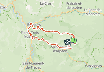
Cevennes 2025 - Bougès jour 6

jm.lemore
User


2h30
Difficulty : Medium

FREE GPS app for hiking
 SityTrail
IGN / Geographical institutes
SityTrail Plus
The world is yours!
About
Trail Mountain bike of 30 km to be discovered at Occitania, Lozère, Cans et Cévennes. This trail is proposed by jm.lemore.
Description
Fait en VTTAE. Circuit niveau moyen. Le petit bout de chemin pour couper la route avant d'arriver à Florac, est une option pour ceux qui aiment les singles difficiles avec gros cailloux et grosses marches.
Positioning
Comments